The terrain of Lao Than is not too dangerous and has an average difficulty level. Therefore, this place is suitable for those who are trekking for the first time or want to experience cloud hunting at an altitude of over 2000m
Difficulty: 1/10

Geography Location
Lao Than is located in Y Ty commune, Bat Xat district, Lao Cai province. It is about 75 km from the center of Lao Cai city. Coming to Lao Cai province, there are also Fansipan Mountain, Pu Luong, Nhiu Co San, and Ky Quan San
Best time to trek to Lảo Thẩn
Lao Than has its unique advantages depending on the time of year. In general, the climbing season here starts from September to April.
If you go from March to May, this is considered the ideal time for cloud hunting because the dry weather, without rain, will make our journey safer.
From September to November is the right time for the rice to ripen. We can combine mountain climbing and admire the eye-catching yellow terraced fields that are typical of the Northwest region.
Finally, if you depart from November to February, you can hunt clouds and trek through the burnt grass forest. The meadow here is no longer green but stands out with a dark brown color with a bit of red. The sparse, deserted forest with a bit of mystery and magic makes us feel like we are walking through a desert like the stories often depict

How to go to Lảo Thẩn
The cloud-hunting journey in Lao Than starts in Hanoi. Several tours take care of your trekking from Hanoi as well. Below, is a detailed guide to help you visualize the journey starting from Hanoi
Hanoi – Sapa section
We will move to Sapa by BUS (about 5 and a half to 6 hours). The reason for choosing to take a bus is because the first road from Hanoi to Sapa is very far, if you travel by motorbike for too long, it will make you tired, so save your energy for trekking and hunting clouds.
When the bus arrives in Sapa, we will have 2 ways to get around:
Rent a motorbike to travel an additional 80 km to Y Ty commune. In this way, you can enjoy the cool mountain air and admire Muong Hum hill and Sang Ma Sao terraced fields on the way.
Rent a bus. Note that if you choose to take a bus, you will find it difficult to avoid motion sickness and nausea. The reason is that the roads have not been improved, and the car is easily shaken when driving. You should bring motion sickness medicine with you.
Y Ty – Lao Than Mountain Base
Once you reach Y Ty, Lao Than is only a short distance away. For your convenience, please find and contact a guide in advance. This way, when you arrive in Y Ty, you can simply go straight to the meeting point (you may discuss with porter or your guiding tour) and start your Lao Than trekking journey
Trekking route

Day 0: Hanoi – Sapa
At Ha Noi, you should choose a bus from 10-11 am the night before to sleep and arrive in Sapa around 4-5 am.
Day 1: Sapa – Muong Khum – Phin Ho – Lao Than Shelter
Early morning (from 5 – 6 AM) Start from Sapa to Muong Khum – Phin Ho (Y Ty)
~ 9-10 AM: Arrive at Phin Ho, rest, and have lunch
Noon: Meet the Porter and leave your luggage to start the journey
Around 6 PM: Arrive at the shelter, start setting up tents and preparing dinner
Day 2: Lao Than Shelter – Mountain Peak – Phin Ho

The distance from the foot of the mountain to the top is only about 8 km (about 16 km round trip). However, to ensure your health, you should climb for 2 days and 1 night to have time to rest and experience the natural space here.
Early morning (from 5 – 6 AM) Wake up, do personal hygiene, and have breakfast.
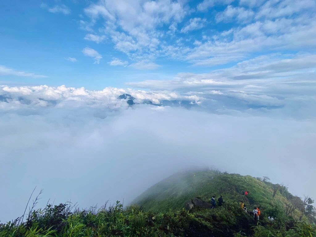
6 – 7 AM: Arrive at the top of Lao Than Mountain, at this time you can experience cloud hunting and watch the sunrise of the day.
8:00 AM: Start moving down to the shelter.
9:30 AM: Clean up tents and belongings at the shelter to move down to the foot of the mountain.
2:00 PM: Go down to the foot of Lao Than Mountain, rest, and eat.
4:00 PM: Experience the bustling market of the Northwest mountainous region.
8:00 PM: Move to Hanoi.
Famous attractions at Lao Than
Fishing Rock
A rugged mountain with a protruding rock. This place is located near the top of the mountain, in a rather hidden position, so you have to pay attention to see it. Because it is high up, the wind blows strong, so when climbing out onto the rock, you need the help of a guide and be careful to stay safe.
