Trekking landscape in Vietnam
Vietnam has diverse terrain, ranging from mountains and hills to plains, coastlines, and continental shelves. Mountains and hills cover about three-quarters of Vietnam’s land area, but most of these are low-lying. The land below 1,000 meters in altitude accounts for 85% of the territory, while mountains higher than 2,000 meters only make up 1%.
Vietnam’s mountains form a large arc facing the East Sea, stretching 1,400 kilometers from the Northwest to the Southeast. The most massive mountain ranges are located in the West and Northwest, with Fansipan Peak, the highest in the Indochinese Peninsula, reaching 3,143 meters. Towards the East, the mountain ranges gradually decrease in height and often end in a low-lying coastal strip.
Therefore, Vietnam has great potential for developing outdoor activities such as mountain climbing, trekking, and trail running. You can purchase the trekking equipment HERE. These activities attract an increasing number of participants, especially young people passionate about experiencing, exploring, and conquering new lands, people, and cultures.
Top 15 breathtaking mountains for trekking
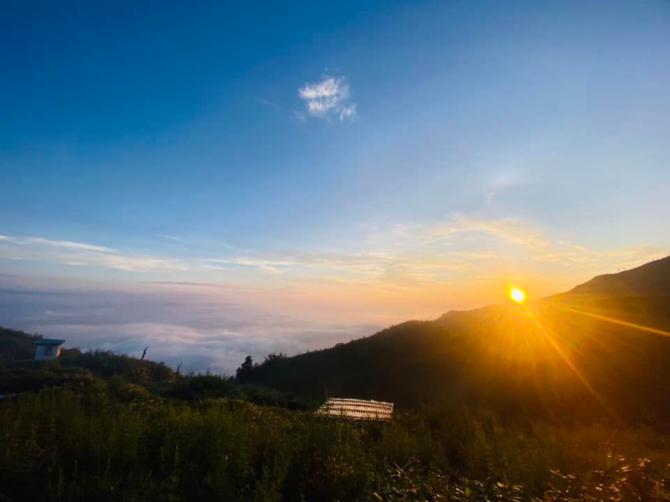
1. Lảo Thẩn
Location: Phìn Hồ Hamlet, Y Tý Commune, Bát Xát District, Lào Cai Province
Height: 2.860m
Difficulty: 1/10
Typical Time: 2 Days 1 Night
Best time: September – February

The Lảo Thẩn trek offers a manageable challenge, making it suitable for even first-time trekkers. As you embark on this journey, prepare to be captivated by the raw beauty of the landscape. Lush green hills, gurgling streams, and peaceful villages will line your path. Trekking to the summit rewards you with a breathtaking panorama – a sea of fluffy white clouds stretching as far as the eye can see, a refreshing breath of fresh air, and a stunning vista of the entire Northwest mountainous region.
2. Nhiu Co San
Location: Sàng Ma Sáo commune, Bát Xát district, Lào Cai province
Height: 2.965m
Difficulty: 2/10
Typical Time: 2 Days 1 Night
Best time: October – April

Nestled in the Bát Xát district of Lào Cai province, Nhiu Co San, also known as Sừng Trâu (Buffalo Horn), is a mountain that promises an unforgettable trekking experience. The diverse terrain and stunning scenery make it a must-visit for nature enthusiasts and adventure seekers.
The initial ascent takes you through low hills covered in bushes, grasslands, and rocky cliffs. As you are trekking higher, you’ll enter a pristine forest with towering trees and colorful maple leaves, reminiscent of a European fairy tale. One of the highlights of Nhiu Co San is the Ong Chúa Waterfall. Cascading down from a height of hundreds of meters, the waterfall resembles a giant white silk ribbon.
3. Chung Nhía Vũ (Da Hai San)
Location: xã Nậm Xe, huyện Phong Thổ, Lai Châu
Height: 2.918m
Difficulty: 3/10
Typical Time: 2 Days 1 Night
Best time: May

Standing tall at 2,918 meters, Chung Nhia Vu is the 10th highest mountain in Vietnam. The mountain’s near-pristine ecosystem is a sight to behold. Towering trees, some reaching up to 50 meters in height, dominate the landscape. This untouched beauty is attributed to its remote location and its status as a natural border between Vietnam and China, under the management of the Border Guard Force. Trekking to the summit follows a stream, making it a truly unique and unforgettable experience. The stream, which is both large and incredibly beautiful, adds to the charm of the journey.
4. Tả Liên Sơn
Location: Tả Lèng commune, Tam Đường district, Lai Châu province
Height: 2996m
Difficulty: 3/10
Typical Time: 2 Days 1 Night
Best time: Aug – Oct

Tả Liên Sơn is a mountain located in Tam Đường district, Lai Châu province, Vietnam. It is known for its stunning scenery and diverse flora and fauna. The trek to Tả Liên Sơn is a challenging but rewarding experience. The trail winds through a pristine forest, with towering trees, lush vegetation, and colorful flowers. The highlight of the trekking journey is the summit of Tả Liên Sơn, which offers panoramic views of the surrounding mountains and valleys. On a clear day, hikers can even see the city of Lai Châu in the distance.
5. Fansipang
Location: Hoang Lien Son Mountain Range
Height: 3143m
Difficulty: 4/10 (2D1N) , 6/10 (3D2N)
Typical Time: 2 Days 1 Nights, 3 Days 2 Nights
Best time: Oct – May

Towering over the Hoang Lien Son mountains, Fansipan is the highest peak in Vietnam, reaching a majestic 3,143 meters. Nicknamed “The Roof of Indochina,” it beckons adventurers and nature enthusiasts alike. Trekking to the summit is no easy feat, but the accomplishment is truly glorious. After conquering dozens of smaller peaks and traversing over 20 kilometers of mountainous terrain, you’ll stand proudly atop the highest point in Indochina, a true Vietnamese conquering the highest point of their homeland.
6. Ngũ Chỉ Sơn
Location:Tả Giàng Phình commune, Sapa district, Lào Cai province
Height: 2.858m
Difficulty: 4/10
Typical Time: : 2 Days 1 Nights
Best time: October – March

Trekking Ngũ Chỉ Sơn, or Five Fingers Mountain, is an adventure. The mountain’s unique formation, with its five peaks resembling a hand reaching toward the sky, has captivated the imagination of locals for generations, weaving it into numerous myths and legends.
The journey to the summit is a challenging one, taking you past majestic waterfalls and streams, through pristine forests, and over chilling cliffs where the wind howls eerily. But the sense of accomplishment and the breathtaking views from the top make it all worthwhile.
7. Khang Su Văn (Phàn Liên San/ U Thái San)
Location:Pa Vây Sử commune, Phong Thổ district, Lai Châu province
Height: 3.012m
Difficulty: 4/10
Typical Time: 3 Days 2 Nights
Best time: Year round

The trek to Khang Su Văn is an unforgettable adventure for experienced hikers seeking a challenge. While the initial climb to the ranger station is manageable, the infamous “dốc 3h” demands strength and skill. Trekkers are rewarded with breathtaking scenery, including a primeval forest and the majestic border marker 79, Vietnam’s highest. Though reaching the peak itself requires some bushwhacking, the sense of accomplishment at the summit is unparalleled.
8. Ta Chi Nhu
Location: Trạm Tấu, Pu Luông, Hoàng Liên Sơn Mountain Range.
Height: 2.979m
Difficulty: 5/10
Typical Time: 2 Days 1 Nights
Best time: October – April

Unveiling a sea of clouds and boasting the otherworldly Chi Pâu flower, Ta Chi Nhu offers a dreamlike trek for experienced hikers. While the challenging 8km climb demands good fitness, the reward is unparalleled – breathtaking panoramas and a summit painted purple during wildflower season (September-November). Remember, this trek is best attempted during the cool, dry months (September-April) for optimal conditions and the chance to witness this mountain’s true magic.
9. Lung Cung
Location: Nậm Có Commune, Mù Cang Chải District.
Height: 2.913m
Difficulty: 5/10
Typical Time: 2 Days 1 Nights
Best time: September to April

Trekking Lùng Cúng is an adventure for those seeking a challenge and stunning scenery. While the hike is difficult with steep inclines and rough terrain, the payoff is incredible. Traversing through remote villages, encountering cascading waterfalls, and spotting colorful wildflowers will leave you breathless. Reaching the summit before dawn and witnessing a sea of clouds below is an unforgettable experience
11. Ta Xua
Location: Bản Công, Trạm Tấu District, Yên Bái
Height: 2.865m
Difficulty: 6/10
Typical Time: 2 Days 1 Nights
Best time: October – April

Tà Xùa, located in the Yên Bái province of Vietnam, is a trekker’s paradise. The mountain, which rises to 2,865 meters above sea level, offers stunning views, challenging trekking, and unique natural features.
The “Sống Lưng Khủng Long” (Dinosaur’s Back) is a particularly popular attraction. This narrow ridge, covered in lush vegetation, juts out from the mountainside and offers panoramic views of the surrounding landscape. Going trekking must be sure-footed and have a head for heights, as the path is narrow and exposed. The mountain is also home to an ancient forest, filled with towering trees and thick moss.
11. Kỳ Quan San (Bạch Mộc Lương Tử)
Location:Trung Lèng Hồ, Bát Xát, Lào Cai
Height: 3046m
Difficulty: 7/10
Typical Time: 3 Days 2 Nights
Best time: Oct-April

Trekking to Bạch Mộc Lương Tử is challenging but rewarding. The trail is long and steep, with some sections requiring scrambling over rocks and boulders. However, the views from the summit are simply breathtaking. On a clear day, you can see for miles in every direction, taking in the stunning mountain scenery of Northwest Vietnam.
12. Putaleng
Location:Tả Lèng Commune, Phong Thổ District, Lai Châu Province
Height: 3.049m
Difficulty: 7/10
Typical Time: 3 Days 2 Nights
Best time: December – March

Trekking to Putaleng is an adventure that many people dream of. Located about 20 kilometers northeast of Lai Chau city, Putaleng is the second-highest mountain in Vietnam, with an altitude of 3,049 meters. While Fansipan is known as the “roof of Indochina”, Putaleng is a roof that many young people and backpackers want to conquer at least once. The layers of white clouds against the blue sky and the green mountains create a truly breathtaking picture.
13. Pờ Ma Lung
Location:Bản Lang Commune, Phong Thổ District, Lai Châu Province
Height: 2.967m
Difficulty: 8/10
Typical Time: 3 Days 2 Nights
Best time: May

The name Po Ma Lung means “White Dragon” in the language of the H’Mong people. The mountain is said to be named after a legend about a white dragon that lived in a lake at the foot of the mountain. The dragon was said to have disappeared after a landslide, and the lake was filled in.
Po Ma Lung is a challenging trekking route, but it is also a rewarding one. The mountain is home to a variety of plants and animals, including many rare and endangered species. The views from the top of the mountain are simply stunning
14. Nam Kang Ho Tao
Location:Hố Mít Commune, Tân Uyên District, Lai Châu Province
Height: 2.881m
Difficulty: 9/10
Typical Time: 3 Days 2 Nights
Best time: October-April

Nam Kang Ho Tao is a remote mountain range located in the Hoang Lien Son mountain range in Vietnam. It is known for its challenging terrain and unpredictable weather, making it a popular destination for experienced trekkers.
The trek to Nam Kang Ho Tao typically begins in the village of Ta Van, Sapa. From there, trekkers must go trekking for several days through dense forests, over steep ridges, and across numerous streams and waterfalls. The final ascent to the summit is particularly challenging, requiring a high level of fitness and technical skills.
15. Pusilung
Location: Ta Leng Commune, Phong Tho District, Lai Chau Province
Height: 3.049m
Difficulty: 10/10
Typical Time: 3 Days 2 Nights
Best time: Dec-March

Trekking to Pusilung, located in Lai Chau province, is an adventure for those who love to conquer high mountains in the northern mountainous provinces of Vietnam. Standing at 3,083 meters high, Pusilung is the second-highest mountain in Vietnam and borders both Vietnam and China. The journey to the top of Pusilung takes 3 days and 3 nights, starting from Hanoi. On the second day, you will reach the summit of Pusilung, where you can enjoy the feeling of accomplishment and the breathtaking views. On the third day, you will descend the mountain and return to Lai Chau.